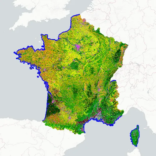
Theia OSO Land Cover Maps over France
Description
The Theia Land‑Cover product (OSO) over mainland France is an automated product generated from Sentinel‑2A and Sentinel‑2B data using the Iota‑2 processing chain. These maps are provided at a 20-meter-resolution. Since 2018, the versions employ a nomenclature of 24 classes, fully compatible with the 17 classes used in the first automatic maps produced in 2016 and 2017. The classification raster is a single raster covering the whole French metropolitan territory. A Random Forest classification model is calibrated using a training dataset derived from a combination of several national and international vector data sources (BD TOPO IGN, Corine Land Cover, Urban Atlas, Référentiel Parcellaire Graphique, etc.).
For more information, please see:
- https://geodes.cnes.fr/projects/oso-occupation-des-sols-raster-l3b/
- https://www.theia-land.fr/blog/projects/occupation-des-sols-hr-france-metropolitaine/ (French webpage)
To use these maps, please use the following citations and DOIs: - 2018: Inglada, J., Vincent, A., & Thierion, V. (2018). Theia OSO Land Cover Map 2018 [Data set]. Zenodo. https://doi.org/10.5281/zenodo.3613415
- 2019: Inglada, J., Vincent, A., & Thierion, V. (2019). Theia OSO Land Cover Map 2019 (Version 1) [Data set]. Zenodo. https://doi.org/10.5281/zenodo.6538321
- 2020: Thierion, V., Vincent, A., & Valero, S. (2022). Theia OSO Land Cover Map 2020 (Version 1) [Data set]. Zenodo. https://doi.org/10.5281/zenodo.6538861
- 2021: Thierion, V., Vincent, A., & Valero, S. (2022). Theia OSO Land Cover Map 2021 (Version 1) [Data set]. Zenodo. https://doi.org/10.5281/zenodo.6538910
- 2022: https://doi.org/10.24400/329360/OSO_20220101_RASTER
Summary
Characteristics
Variables
- Land use
Temporal resolution
1 year or less
Spatial resolution
10 meters
Format
Raster
File format
GeoTiff
Products acquisition
Satellite
Missions
- Sentinel-2
Instruments
- MSI
Identifier
OSO_RASTER_L3B
Release
V1-0